Author: Dr. Salem Y. Lakhal
It was considered an event when the Nordic Barents (Figure 1), a ship registered in Hong Kong, sailed on September 4, 2010 from Norway shipping iron ore to China through Arctic and Russian waters. This vessel used the new maritime route called the “Northeast Passage”. It is the first time a non-Russian flagged commercial bulk carrier used the Northern Sea Route (the Northeast Passage).

Figure1: Nordic Barents sailed from Norway to join China
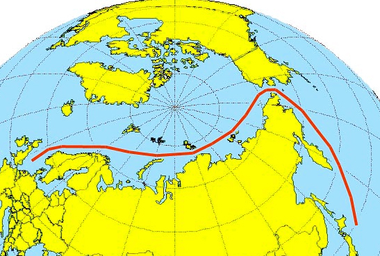
This passage is known also by Russians as “The Northern Sea Route” (NSR) is the shipping lane between the Atlantic Ocean and Pacific Ocean along the Russian coast of Siberia and the Far East and runs through the Barents, Kara, Laptev, East Siberian and Chuck Chi seas (Dubey 2012). The NSR is a shortcut from Asia to Europe (Figure 2)

Figure 2: The NSR is a shortcut from Asia to Europe
In fact, it is the entire corridor which lies north of the Russian Federation in the Arctic. Consequently, the NSR is not a linear route and exact routing or optimal course of ships depends on the ice condition and size of the ships. The NSR route could shorten the voyage distance compared to transits through the Suez Canal for a Far East route, for example a route between London-Yokohama. In fact, fuel savings could be substantial depending on oil price and, the voyage time is cut back by one third (Nerenberg 2010). According to Kireeva and Digges (2012), in 2010, four trips through the Northern Sea Route were completed and 110,000 tons of cargo delivered. In 2011, more than 800,000 tons of cargo was delivered.
Vast implications for the shipping industry will be expected for a trade that was previously dependent on routes through the Suez Canal (Table 1). But, due to large amounts of ice, the Northern Sea Route is rarely open for most of the year, but that is changing with global warming.
Table 1: Ocean route alternatives between Northwest Europe and Far East, with respective approximate navigation distances, in nautical miles (nm). 1 nm = 1.852 km. Adapted from: (Christensen 2009) and (Schøyena and Bråthenb 2011)
| Route | Panama canal | North West Passage | Northern Sea Route | Suez Canal | Cape of Good Hope |
| North West Europe (London) to Far East (Yokohama) | 12,580 | 8600 | 7200 | 11,400 | 14,750 |
| Relative distance | 175% | 119% | 100% | 158% | 205% |
Risks and challenges:
According to Dubey (2012), the Arctic presents some unique risks. Obstacles and challenges are manifold, including the following:
- Remoteness impacting rescue and emergency operations
- Lack of information about safe ports
- Insufficiently detailed charts with white spots
- Inadequately developed infrastructure and their implications on SAR
- Ice/winter related issues – ice accretion, ice damage, restricted visibility and multiple operational problems
- Limited knowledge of local oceanographic conditions
- Increased number of ice floes and icebergs during early melting season
- Lack of reliable weather and ice information and meteorological data Limited knowledge of local oceanographic conditions
- Conventional gyro and magnetic compasses, communication equipment may not function at its optimum level in higher latitudes
- Unavailability of adequate number of ice trained and competent crew.
Furthermore, the Russian legislators adopted in summer 2012 a law on NSR (Russian-Government 2015) and entered into force in 2013, lays down regulations to administer NSR traffic (Ministry-transport-Russia 2013). This law includes:
- Compulsory insurance, thus enhancing ship owners’ responsibility for possible pollution and other environmental damage
- Outlines the level of shipping fees
- Mandatory ice breaker service
- Carriage of ice pilot
- Formal authorization procedure by the Northern Sea Route Administration
- Organize Search and Rescue operation
- Provide radio communication and hydrographic information.
Concerning the third point, Russia is offering ice breaker service with a 200000 USD.
Conclusion
Using the Northern Sea Route has a variety of economic advantages, including swift delivery of cargoes to Asia from Europe and he west. The lack of piracy to which Asia bound cargoes is prone as they pass through the Suez Canal off the coast of Africa. The most disadvantages is, the entire route lies in Arctic waters and parts are free of ice for only two months per year
References
Christensen, S. A. 2009. Are the Northern Sea Routes Really the Shortest? . http://subweb.diis.dk/sw74533.asp.
Dubey, B. K. 2012. Arctic Routes: Emergence of New Trade Link. Hong Kong: Skuld Hong Kong.
Kireeva, A., and C. Digges. 2012. Russia taking on Northern Sea Route as Bellona raises alarm over Norwegian vessels under escort of nuclear icebreakers: Bellona.
Ministry-transport-Russia. 2013. RULES of navigation on the water area of the Northern Sea Route In January 17, 2013 No 7, edited by M. o. T. o. Russia: http://www.arctic-lio.com/docs/nsr/legislation/20130425185806en-Rules_unof.pdf, 1-19.
Nerenberg, J. 2010. The Northern Sea Route is rarely open due to large amounts of ice present most of the year. In Fast Company.
Russian-Government. 2015. Northern Sea information Office, edited by http://www.arctic-lio.com/nsr_legislation.
Schøyena, H., and S. Bråthenb. 2011. The Northern Sea Route versus the Suez Canal: cases from bulk shipping. Journal of Transport Geography 19 (4):977–983.